Why having a snowmobile GPS is vital? Riding a snowmobile can be much alike to planning a military invasion. You can get your gear going, your supplies ready and your engine ready to rumble. But one thing is for certain. If you get yourself and all of that stuff with you in places you have no idea how to navigate, good luck then. And speaking of luck, many don’t even get to be lucky. This is why winter is a nightmare for any search party out there.
Picture it like this: you get your sled into the middle of nowhere, without enough supplies and with no knowledge of the terrain. You are alone, thinking that nothing bad could happen to you and that you will return to your trailer by sunset.
And then it hits you. Your sled gets stuck in the muck and you have virtually no possibility of dragging it out. Because of the much, your gear, which was strapped either to you or the sled is wet and already freezing. You have no signal, no map and you ”forgot” to tell anyone where you will ride because you just ”follow the wind”.
With no means of communication available, you want to abandon your stuff out there to search for a safe place. But you don’t want to risk losing all your money, because nothing bad could happen to the main character of your story.
Fast forward you are left with no supplies, help, knowledge of the surrounding area and in a sub-zero temperature. You slowly start to lose both your body heat and your grip on reality, until you flat out leave this plane of existence.
Despite sounding harsh, this is what hundreds of riders experience each year due to not bringing a good GPS.
The best?
Here are three highly recommended models:
GPS: what and why
 For those amongst you living under a snowy rock, a GPS or Global Positioning System is a satellite-based radio-navigation system. It is a global navigation satellite system which provides geolocation and time information to a GPS receiver.
This requires the GPS to sit in the ”line-of-sight” of four or more GPS satellites in order to function properly. Meaning that there must be an unobstructed line of sight to said satellites, given the relatively weak GPS signals. This factored in with obstructions like buildings, trees and mountains lead to the rider being left blind on some occasions.
But before you close this article on the presumption that GPS is a bad idea, let me tell you how it isn’t. At first, I was also reluctant to the idea of being ”blinded” and stranded, but then it hit me. What better solution is there? Yes, you might risk some with throwing your entire lot with something that, in the wrong circumstances, will screw you up good. But life cannot be all milk and honey. And this is a risk you will have to endure to make sure you don’t end up like the guy from the introduction.
I might be sounding very pessimistic, but you need to know what you are getting yourself into. There are far worse ways of managing your unknown location, but this is by far the most commonly used one. And are also effective, next to physical maps, of course, seeing as how they have a tendency of not running out of batteries.
Benefits of use
The Global Positioning System application acquaints for the following five main functions:
-
Location
In the scope of determining your location, the GPS makes use of the grid system of intersected points. In other words, coordinates are expressed as a combination of latitudinal and longitudinal indications.
Latitude is measured from the Equator which is 00 to the poles, which are 900. The Prime Meridian is 00 longitude and the locations are measured according to 900 east or west of that point.
For example, if you were to take a snowmobile trip around the Finland town of Ranua, your GPS will read:
65055’43.4”N and 26028’53.3”E
Although it is generally considered that it is not our job to decipher such mambo-jambo, this numerical information feeds into the GPS. This, in turn, added to the already existing geographical information, allows the GPS to translate into the next point: mapping.
-
Mapping
For your safety, your GPS will require an exceptionally good mapping software. Usually, GPS systems will come with one already pre-installed. It might not always be the best of the bunch, but it will prove to be a useful tool.
GPS systems function at an international level, due to it being the equivalent of an IT open-source project. There are numerous entities and people out there who take up the attribute of going around the world to gather geographical information. This information is then ”fed” to the ”hive-mind” and the process only betters the software all-around.
The best example to use here is Google Maps. However, seeing as how it usually maps only circulated roads and populated places, you shouldn’t rely on it. Fortunately, however, people across the globe take to gathering this information themselves, usually for the backcountry types of regions. And you could also do this. If the region you are tracking through isn’t mapped, do it yourself and contribute to the future safety of all riders there.
One might claim that the existence of satellites makes worrying about being lost pointlessly. And to some degree, one might be right. However, there is a slight disadvantage in determining your location through Google Maps. It requires wifi. Yes, both the wifi and GPS signals work through satellites. However, the wifi method requires a constant, strong connection, which many countries simply do not offer. On the other hand, GPS signals work permanently, unless they are hindered by large obstacles, like mountains or solar storms.
-
Timing
Longitude, latitude, and altitude are the key factors/dimensions that help us navigate. There is, however, a fourth dimension: time.
For the first two elements, you could determine this information with only a map and some knowledge of geographical orientation. This third element is what makes the GPS such a useful tool.
Next to showing the surroundings, it will also display your current location in accordance to the present moment. So while using a map you would have to be attentive to your surroundings for identification, the GPS will do it for you. This is especially useful when you are tracking through coasts, water-ways, plains and other such terrains with few reference points.
Each GPS satellite contains numerous atomic clocks that contribute very precise time-data to the GPS signals. Then, your GPS receiver decodes this satellite information and allows the wielder to determine his position in regards to time. And this is done within 100 billionths of a second, without you having to own an atomic clock.
Currently, GPS modernization programs are adding dedicated civil signals at L2 that supports high-accuracy positioning without military signals. Why am I saying this? Because, once upon a time, the GPS was made and used exclusively by the military. Just like TOR and other such services, which then were placed at the disposal of ordinary folks. With every passing day, improvements and new applications are made, so the GPS will become even better and safer for civilian use.
-
Tracking
None of those five elements work alone. All of them act together so that you can access the exact information regarding your location on the map in real-time. While the location, mapping and timing functions feed info into the GPS, the tracking function places you on the map.
This means that, through all that information, your devices’ movements are constantly visualized, updated and tracked.
Out on the market, you can find three types of GPS trackers:
- Data loggers – they log your position at regular intervals of time. They function either through a memory card slot, internal flash memory card or a USB port. Some of them function as USB flash drives, allowing the download of their contents on computers. Although there are multiple formats, the main three used by data loggers are GPX, KML, and NMEA.
- Data pushers – the bread and butter of the bunch and the one you will most probably use. Those are the most commonly used types, meant for the asset, personal and vehicle tracking. Also known as ”GPS beacons”, they periodically emit information towards the ”hive-mind”, allowing for high-end levels of tracking. This means that your location will be constantly updated, with a 95%+ rate of efficiency. But don’t be all too relaxed, because do you remember mountain-jamming? This is the best solution there is for now, but always keep a map on you.
- Data pullers – while the pushers emit info, the pullers receive it (duh). Also known as transponders, they are permanently working and receiving information. This means that you can update inquire info at any moment. Best way to describe it is with PC’s and their connection to the Internet. They are not used that much, due to their liability of relying on info coming to them, instead of giving.
-
Navigation
After reading all of the above, you should think of the Power Rangers huge robot. It can’t function without all of its 5 components. The navigation function is the last one but is as important as the rest. Think of it as the ”parkour” function.
With the info fed into your device (location, map and time), all that is left is to plot a course. That is done by using all of that info, taken from at least 24 GPS satellites and according to its analysis of the surrounding area.
Such is the merit of this thing that it can plot the shortest routes possible, with an astounding success. In the middle of nowhere. Talk about efficiency. And all of that can be done with an error margin of between 2 centimeters and 2 meters, depending on the GPS.
It is battery operated
If you had paid attention previously, you might remember how I talked about this one as being a slight disadvantage. It still is -read down below about the disadvantages of GPS-. However, if the benefits wouldn’t exceed the disadvantages, I would flat out tell you to avoid it like the plague. So let us talk about the advantages.
The GPS, being battery operated, can bite you in the arse sometimes, but it is ultimately its biggest advantage. This means that it can be 100% mobile and you can hold as many spare batteries as you can/afford.
There are two types of batteries:
Normal AA batteries: those should be your go-to choices.
Lithium-ion rechargeable batteries: a pioneer and certainly the go-to choice of the future. However, although they seem to be virtually perfect, due to:
- High energy density: the more intense the usage of a device is, the more power it consumes. High energy density will keep a great deal of power available for recharging.
- Lower (than normal batteries) self-discharge: Batteries lose their charge over time, especially in the cold. Those things dampen the discharged energy.
- No requirements for priming: Some rechargeable batteries require priming when first charged. Those do not.
- Low maintenance: Self-explanatory. They will keep their performance even through a lack of maintenance.
They still have its flaws:
- They require dedicated protection;
- They age;
- They are much larger than normal batteries;
- They are expensive;
- They are pioneer-technology.
Something many riders do is that they use, with larger GPS devices, Lithium-ion batteries at first and keep normal AA’s as spares. This means that if one fails to work, the other type will fill any existing power efficiency gap.
It is small and light
 Easy to carry and easy to handle. Due to its very small stature, the GPS is very easy to pack due to it not occupying much of your personal space. Space that you could use to bring other crucial supplies, such as spare batteries, maps, food, water and so on. And its weight will add very little to your overall kit, leading to less fuel consumption.
This is even better when you actually use it, due to being mounted on the handlebar of your sled for easy access.
Easy to navigate
This one speaks for itself by virtue of the GPS doing all the all/most of the navigation for you. Things like distance, direction, time, speed and others are thoroughly calculated and provided by the system in real-time very accurately. This will allow you to free your mind and have lots of fun, instead of stressing over every corner, log and nock.
However, I cannot stress you enough with this: always carry a map and pay attention to your GPS. Should it fail, it will then fall upon you to navigate accordingly. Use your last known location as a pin-point to navigate further according to your map.
Works at all times
Unless it is not hindered by either loss of battery life or geographical barriers, it should work in any type of weather. However, there can be complications. Ironically, one of them is that which will surround you most – snowfall. But unless we are talking about monsoon-levels of a blizzard, the worst you will experience will be some slight delays of the signal. This can be even worsened if the antenna gets covered by a thick layer of snow/ice, so clean it whenever you can.
But ultimately, you shouldn’t be that much afraid. Although the signal may decrease in quality due to weather conditions, it will persevere.
Low costs
Remember two things:
- GPS is an international investment made by a lot of countries worldwide; and
- It was once meant only for exclusive military use by the US Army.
Although it was only limited to the US army in the beginning, now many countries invest heavily in such systems. To put it into perspective, only the Pentagon’s GPS costs 2mil$ per day (750mil$ annually). So even if the information of the system is free, your usage is not.
But don’t fret. Because it is highly affordable. On average, ”subscription” by renting or purchasing costs somewhere in between 20$ – 30$ monthly. And seeing as how winter is limited to only a few months, the investment is really obsolete.
It is regularly updated
The GPS is being both connected to numerous satellites in orbit and being fed information by millions of users worldwide. Thus, it comes as no surprise that due to a steady and rich influx of information, the system is getting better and better by the day.
Disadvantages
It is vulnerable to ”roadblocks”
The greatest disadvantage of a GPS. For starters, it has to listen to the vague signals of a bunch of satellites 25.000km away. And for it to function, it will need at least 4 of them. Well, when you have something blocking said signals: mountains, canyons, and urban canyons, you are in a pickle. It requires constant access to said signals, while its own signal has the power of a sad light-bulb. And although there are some systems specially designed for mountains which work like angels up there, don’t bet on them. They are highly specialized and as such, very expensive. As a final note to this, always carry a map.
It is battery operated
Like us humans, batteries work best at room temperatures (200-ish). Due to the often sub-zero temperatures, you will experience while tracking, the batteries will always be at risk of failure. Cold temperatures increase internal resistances but decrease their capacity, often even by 50%. This will ultimately force you to always pack an additional external power supply (if data logger) or batteries (if pusher-puller).
Not only will this add to your overall expenditure, but in the case of batteries, you will risk freezing your spares. Also, in the case of an external source, it might become dry and leave you stranded. For this reason, you should always pack a map.
The best on the market
After all of this mambo-jambo, we finally get to the requested part: what GPS is the best?
In no particular order, here follows a trio of the best and most commonly used GPS receivers out there by riders:
Trail Tech 912 Voyager (around 260$-270$)
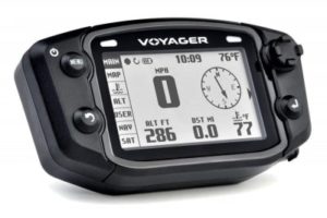 One of the best 2018 off-road GPS for all riders out there, meaning that it was made to fit not only snowmobiles but also A.T.V’s, dirt bikes, etc. It is not just plain and simple, but also small and light, providing top-notch and accurate tracks even in the toughest terrains.
Due to its back-lit 240 X 400 WQVGA LCD screen display, it will reliably tell you the: speed, distance, compass, altitude, ambient, engine temperature, maps, and position. This while also boasting a customizable user screen.
Speaking of screens, this one still has something to show. Its track manager CD will allow you to view, organize, edit and share entire trail systems in 3D. It is waterproof, both externally and around the MicroSD card, thus protecting it from any unscrupulous weather. It also allows for online accessibility. We are, however, talking about downloading and sharing maps, not pictures.
Its last/nicest feature is, however, its data-logging ability. What this does is that when your engine stops, it will automatically cease any trail logging. This will eliminate any random data points from your track when not you’re moving. Click here to check the current price on Amazon.
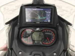
Garmin GPSMAP 64st, TOPO US 100k (around 270$-290$)
 Another fan-favorite. In essence, it is not far away from its Trail Tech counterpart. The foremost defining feature of GPS receivers is that they are made to last and to last in bad weather. But what is such resistance good for if you aren’t able to get a read on due to strong sun rays?
In comes one of its unique features. It boasts a Sunlight-Readable 2.6” display size of 1.43 X 2.15 and 2.6 inches diagonal screen with a 160 X 240 pixels display resolution. This means that is made so that you can read it even under an open sky with a strong sun. Not only that, but many others to follow:
Remember when I talked about batteries? Well, this one has a battery life of 16 bloody hours, even without the spares you will bring. Speaking of batteries, it also has a dual battery system that uses either 2 traditional AA batteries or the rechargeable Ion one. If you are going to use AA’s, the Polaroid ones are the best with it.
Not only does it have an internal memory capacity of 8gb, but its interface is also high-speed USB and NMEA 0183 compatible.
But the icing on the cake lies with its smart-function. It can receive Smart Notifications and pair with optional ANT+ sensors, such as heart rate monitor, temperature sensor, speed, and cadence. Hell, it can even be used to control your VIRB action camera (64s/64st only though).
As a final note, due to being so smart, it can connect with your smartphone and upload data to Garmin Connect. This can be used to share whatever activities you are doing though Live Track. Click here to check the price on Amazon.
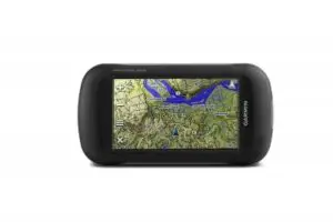
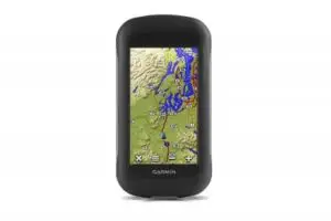
Garmin Montana 680t (600$)
 The ”top gun” of the trio. Investment always (usually) yields great results. And boy-oh-boy, this one delivers. Where should I start?
Maybe with the fact that this thing is as much a smartphone as it is GPS. Why? First, because due to its wireless function, you can share all of your maps with every other Garmin user worldwide. And you will have quite a selection of maps to choose from. This thing comes packed with over 100.000 geocaches for you to use and abuse. Also, due to its 8-megapixel autofocus camera, you can share info in real time with anyone out there. Also, it is perfect for taking Geotagged pictures (includes coordinates). Although you will need to buy a separate MicroSD card for extra memory, those photos can be tracked back by anyone. This is topped only by its 3-axis compass with a barometric altimeter.
Not only that, but it can track both GPS and GLONASS satellites and comes with a 1-year BirdsEye Satellite Imagery subscription. This makes it ideal for any type of outdoor activity: hiking, riding, tracking, and mountaineering.
This is also due to it being very easy on the eye. Its 4-inch dual orientation, glove-friendly touchscreen display does wonders on the tired eye. Like its counterparts, it also boasts a dual battery system (AA or lithium-ion rechargeable), is water resistant and is very easy to mount and carry. Check it out here.
Other besties:
Nuvi 50, 50LM, 52LM 54 (190$-240$)
Trail Tech 912-502 Voyager Stealth Black Moto-GPS Computer (250$-290$)
Garmin eTrex 30x Handheld Navigator (200$-300$)
Conclusion
Choosing the best GPS out there, like anything else, revolves around how much you invest in it, how good you want it to be and how much care are you going to give it. And even cheaper ones do their job well, as most riders don’t have hundreds of dollars to invest only in the GPS.
Just make sure to follow all the necessary safety procedures and to double check everything. On a side-note, never forget your map at home. Until next time, ride safely!